1. Data Set Overview:
-
Data Set Identification:
- GEOS-3 Altimeter Geophysical Data Record '75-'78
-
Data Set Introduction:
- These data consist of Geos-3 altimeter measurements produced by NOAA/NODC/Laboratory for Satellite Altimetry. The data set contains 5,006,956 altimetric sea surface heights and supporting information such as sea state, wind speed, Schwiderski ocean tide height, and Cartwright solid-tide height. Corrections for altimeter bias, wet and dry troposheric delays, and electromagnetic bias are not included. The corrections in this data set (tides and even orbit height) are old and not very accurate. This data set should only be used by those with expertise in altimetry. Measurements are compressed to a rate of 1 per second using a trim mean filter. Data values are written in binary format. Read software is provided.
-
Objective/Purpose:
- The GEOS-3 Radar Altimeter is a precision satellite radar developed primarily to measure ocean surface topography and sea state.
-
Summary of Parameters:
- Sea Surface Height
Significant Wave Height
Ocean Wind Speed
-
Discussion:
- GEOS-3 data were provided in two different forms by the NASA Wallops Flight Center. These include a complete 10-per-second set of "I" tapes and a compressed 1-per-second set of "G" tapes. The "I" tapes were reprocessed and edited to form this NOAA NOS/NGS 3.5-year data set.
-
Related Data Sets:
- TOPEX/POSEIDON Altimeter Merged Geophysical Data Record
2. Investigator(s):
-
Investigator(s) Name and Title:
- John L. Lillibridge
NOAA Laboratory for Satellite Altimetry
http://ibis.grdl.noaa.gov/SAT/ -
Title of Investigation:
- GEOS-3 Mission
-
Contact Information:
- Please direct all queries regarding GEOS-3 data to:
User Services Office
Physical Oceanography Distributed Active Archive Center (PO.DAAC)
Jet Propulsion Laboratory (JPL)Phone: (626) 744-5508
Fax: (626) 744-5506
Email: podaac@podaac.jpl.nasa.gov
URL: http://podaac.jpl.nasa.gov
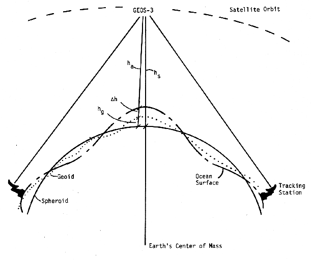
3. Theory of Measurements:
- ha = hs - hg - dh
GEOS-3 Satellite Altimeter Geometry
4. Equipment:
-
Sensor/Instrument Description:
-
Collection Environment:
- satellite
-
Source/Platform:
- The GEOS-3 spacecraft was launched on April 9, 1975 from Vandenberg, California, into a near nominal 843 km circular orbit with an inclination of 115°.
-
Source/Platform Mission Objectives:
- The purpose of the GEOS-3 mission was to design, develop, and launch a geodetic satellite and to perform experiments in support of the application of geodetic satellite techniques to geosciences, that is, solid earth physics and oceanography.
-
Key Variables:
- The GEOS-3 altimeter is a complex multimode radar system with two distinct data gathering modes, Global and Intensive. Both operate at a frequency of 13.9 GHz.
-
Principles of Operation:
- Aboard GEOS-3 is a radar altimeter for measuring the ocean
surface characteristics and the spacecraft to ocean surface
distance; frequency of operation is 13.9 GHz, with two modes of
operation: global or long pulse (200 nsec) mode, and intensive or
short pulse (12 nsec) mode. For trajectory determination there
are a coherent C-band transponder, S-band transponders for
communication with high altitude satellites, laser
retroreflectors, Doppler transmitters, a non-coherent C-band
transponder and an S-band transponder for communication with
earth tracking stations.
Within battery power constraints, altimeter data can be taken whenever the satellite is within view of a telemetry site, with data always transmitted in near real time. No storage of data is possible on board the spacecraft, although some averaging of data prior to transmission is possible. In addition transmision may also be via an S-band link through ATS-6, so that more than half a revolution of continuous visibility of GEOS-3 is possible for those missions for which ATS-6 is scheduled.
-
Sensor/Instrument Measurement Geometry:
- The orbit has an inclination angle of 115° so succesive tracks will cross the equator every 101.8 minutes with a precession of about 26°. Thus for any given region the satellite will cover a 1° x 1° grid in approximately one month.
-
Manufacturer of Sensor/Instrument:
- The GEOS-3 spacecraft was designed and fabricated by the Applied Physics Laboratory (APL) of the Johns Hopkins University. The GEOS-3 Radar Altimeter was designed, developed, manufactured, tested, and qualified by the General Electric Company Aerospace Electronic Systems Department (AESD) with the Applied Physics Laboratory.
-
-
Calibration:
-
Specifications:
- The GEOS-3 radar altimeter has two modes of operation (Global and
Intensive) and two corresponding self-test/calibration modes for
use in on-orbit functional test and instrument calibration.
The major calibrations considered necessary for the built-in test/calibration system were time delay (bias), AGC/gain, and waveform calibration. Internally generated signals are provided for calibration. A 10-second time delay (bias) test is performed in each mode to determine the bias to within the required one meter. In each mode, a two-point AGC/gain calibration is obtained using IF reference pulses. For waveform calibration, controlled video waveforms are used in both modes. [Hofmeister et al., 1976]
-
Frequency of Calibration:
- Each mode has a pre-determined calibration cycle which includes a test for each of the above three functions.
-
Other Calibration Information:
- For more information, refer to "Calibration Results for the GEOS-3 Altimeter" [Martin and Butler, 1977].
-
5. Data Acquisition Methods:
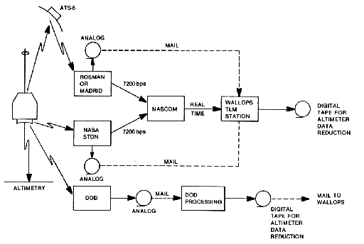
The figure below displays the flow of raw telemetry data employed during the GEOS-3 mission. Data acquired at the NASA STDN sites (including ROSMAN and Madrid ATS-6 stations) were routed to the NASA Wallops telemetry station eigher in real-time using data communications, or analog tapes were recorded at the sites and then mailed to Wallops. At the Wallops telemetry station, the data (either real-time or on analog tapes) were digitized to provide a computer campatible tape for further processing in the altimeter data reduction programs. In the case of data acquired at the DoD telemetry sites, these data were digitized by DoD and made available for processing at Wallops in the same altimeter data reduction programs. [Stanley and Dwyer, 1980]
GEOS-3 Data Flow
6. Observations:
-
Data Notes:
- No additional notes.
-
Field Notes:
- No additional notes.
7. Data Description:
-
Spatial Characteristics:
-
Spatial Coverage:
- Global
-
Spatial Coverage Map:
- This information is not available at this time.
-
Spatial Resolution:
- Ground track separation is approximately 25.32° longitude from one revolution to the next.
-
Projection:
- This information is not applicable for this data set.
-
Grid Description:
- This dataset is not gridded! Measurements are sampled along subsatellite tracks.
-
-
Temporal Characteristics:
-
Temporal Coverage:
- 14 April 1975 - 1 December 1978
-
Temporal Coverage Map:
- This information is not available at this time.
-
Temporal Resolution:
- The day to day (14 revolution) separation of subsatellite tracks is 5.47°.
-
-
Data Characteristics:
- Sea Surface Height - the smoothed sea surface height above the ellipsoid, without tide or other model corrections (mm).
- Significant Wave Height - the average height of the one-third highest waves of a given wave group (cm).
- Ocean Wind Speed - scalar value of the magnitude of the wind speed at the ocean surface (cm/sec).
-
Sample Data Record:
- This information is not available at this time.
8. Data Organization:
-
Data Granularity:
- A general description of data granularity as it applies
to the EOS Data Gateway (EDG) appears in the
EOSDIS Glossary.
- The data are organized into one gzipped direct-access file of GEOS-3 GDRs, geos3.daf.gz. The data volume for the entire data set is ~260 MB.
-
Data Format:
- The data have a logical record length of 52 bytes and are composed of
4-byte and 2-byte integer fields, as outlined in the table below.
The records appear in chronological order and are separated into passes by the presence of header records before the first data record of each pass. The header records were inserted when either a time gap exceeding 15 seconds occurred in the data or the pass traversed more than the physical limit, approximately 12,400 sq km.
GEOS-3 Altimeter Data Records
FIELD   BYTES   UNITS           CONTENT
-----   -----   -----         ----------------------------------------------
1       1-4     DAYS          MODIFIED JULIAN DATE OF OBSERVATION
                              (JULIAN DATE - 2,400,000.5 DAYS)
2       5-8     SECONDS       TIME FROM BEGINNING OF DAY
3       9-12    10**-6 SECS   CONTINUATION OF TIME TO THE MICROSECOND
4       13-16   10**-6 DEG    GEODETIC LATITUDE
5       17-20   10**-6 DEG    EAST LONGITUDE
6       21-24   MM            SMOOTHED SEA SURFACE HEIGHT ABOVE ELLIPSOID
                              WITHOUT TIDE OR OTHER MODEL CORRECTIONS
                              (A = 6378145 METERS, F=1/298.255)
7       25-28   MM            SATELLITE HEIGHT ABOVE ELLIPSOID
8       29-30   MM            SCHWIDERSKI TIDE HEIGHT ABOVE MEAN SURFACE
                              WITH 9 TERMS INCLUDED (M2, S2, K1, O1, N2,
                              P1, K2, Q1, MF)
9       31-32   MM            CARTWRIGHT'S SOLID TIDE HEIGHT WITH ZERO
                              FREQUENCY TERM NOT INCLUDED, H2=.61, H3=.29
10      33-34   CM            H 1/3, SIGNIFICANT WAVE HEIGHT
11      35-36   10**-3        SURFACE REFLECTIVITY (SIGMA NAUGHT)
12      37-38   CM/SEC        WIND SPEED
13      39-40   10**-2        SWELL COEFFICIENT (GAMMA)
14      41-42   10**-4 DEG    POINTING ANGLE
15      43-44   10**-2        FRAME AVERAGE MEAN SQUARED SLOPE
16      45-46   10**-2 DB     AUTOMATIC GAIN CONTROL
17      47-48                 INDEX OF ICE PROBABILITY
18      49-50                 REVOLUTION NUMBER OF ORBIT
19      51-52                 STATUS BITS (1,2,3,...16)
                              1     0 (INTENSIVE), 1 (GLOBAL) MODE
                              2     0 (), 1 (MODIFIED KALMAN EDIT)
                              3     0 (LOW), 1 (HIGH) DATA RATE
                              4     0 (ALL), (ANY/ALL NON) AUTO TRACK
                              5     0 (NO), 1 () APG/AASG EDIT
                              6     0 (NO), 1 (ORIGINAL) KALMAN EDIT
                              7-16  0 (WATER, 1 (LANDOR ICE)
                                      THIS 10 BIT FIELD REPRESENTS LOCATIONS
                                      ALONG THE GROUND TRACK SPACED AT .1024
                                      SECONDS
9. Data Manipulations:
-
Formulae:
- This information is not available at this time.
-
Data Processing Sequence:
- This data set was reprocessed from the original "I" tapes. The "I"
tapes contain smoothed sea surface heights at the rate of 10 per
1.024 seconds. However, each record represents one frame of data and
contains either 20 or 32 samples depending on whether the data were
taken in the low- or high-rate mode. In deciding how to compress
these values to 1 per second, simplicity and placement of evenly
spaced observations were given priority. With the belief that no
information existed under one second in the GEOS-3 observations, and
at the same time wishing to disregard occasional outliers, a trim
mean filter was selected to compress the "I" tape heights.
Multiples of 20 or 32 observations per frame led to selecting a 10-point filter for low-rate data and an 8-point filter for high-rate data. In both cases, the largest and smallest values were removed and the remaining 8 or 6 points meaned. The means were assigned times at the midpoint of the 10- or 8-point span to preserve equal spacing. Consequently, passes of low-and high-rate data have different spacing of about 1.024 and 0.8192 seconds, respectively.
The other variables were computed in a manner that maintains the original precision. The latitude and east longitude values were linearly interpolated from frame values; satellite heights were quadratically interpolated. The Schwiderski oean- and Cartwright solid-tide heights are computed independently of the altimeter tapesi using software developed by Clyde E. Goad of NGS. The ocean tide computation consists of the M2, S2, K1, O1, N2, P1, K2, Q1 and MF components. The solid-Earth tide ignores the zero frequency term and uses values of H2=0.61 and H3=0.29.
The remaining fields of each compressed data record are frame values except for the automatic gain control (AGC) and the status bits. The AGC is a mean of the eight or six values corresponding to the trimmed set of sea heights. There are two or four relevant status samples per frame for the low-or high-rate data.
-
Calculations:
- This information is not available at this time.
-
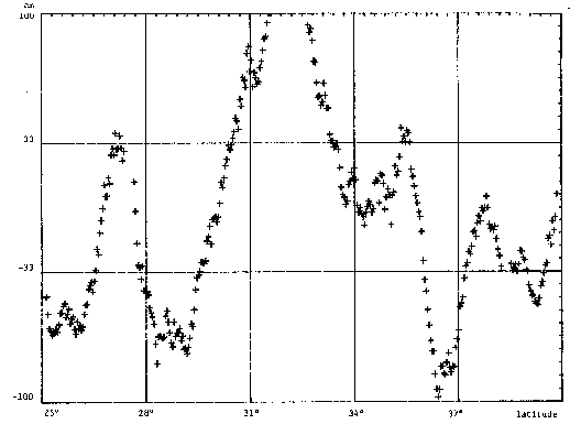
Graphs and Plots:
- Figure 1 shows the height resulting from a pass of altimeter data
in the northwestern Atlantic ocean. The approximate geoid
undulation along the pass has been removed so that the "noise"
in the heights can be seen. The compressed observations which
are contaminated with several outliers appear to have an
uncertainty of about 20 cm. Further smoothing is required.
Figure 2 shows the heights after smoothing with a 7-point
trimmed mean running filter. The trimming was confined to the
largest and smallest values. [Agreen, 1982]
Figure 1. Compressed surface heights, April 19, 1976
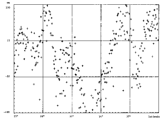
Figure 2. Smoothed surface heights, April 19, 1976
10. Errors:
-
Sources of Error:
- For information on sources of error, refer to "Altimeter Error Sources at the 10-cm Performance Level" [Martin, 1977].
-
Quality Assessment:
- Data from the GEOS-3 altimeter was analyzed, for both the intensive
and global modes, to determine the altitude bias levels for each mode
and to verify the accuracy of the time tags which have been applied
to the data [ Martin and Butler, 1977].
The best estimates of the biases are
Intensive Mode -5.30 m ± 0.21 m Global Mode -3.55 m ± 0.42 m NOTE: The negative signs indicate that the measured altitudes are too short. The data is corrected by subtracting the above bias numbers for the respective modes.
The time tag correction that should be applied consists of
-20.8 msec + 1 interpulse period (10.240512 msec).
11. Notes:
-
Limitations of the Data:
- Since no data memory is available aboard the satellites, altimeter
data aquisition is limited to areas where telemetry stations are
located.
The noise figure of the GEOS-3 altimeter coupled with orbital tracking errors have prevented the direct use of this altimetry data in detailed studies, such as ocean circulation and surface velocity.
-
Known Problems with the Data:
- Roughly six weeks of observations are missing.
-
Usage Guidance:
- Corrections for altimeter bias, wet and dry troposheric delays, and
electromagnetic bias are not included. The corrections in this data set
(tides and even orbit height) are old and not very accurate.
Since no further attention was given to the original observations beyond each 8 or 10 points, there were occasions when a group of partially or completely bad heights was compressed to a single bad height. Thus, users of the data must be cautious of these spurious values. The decision to keep these values on the tape was primarily based on the consideration of simplicity and respect for the other data fields which might be useful to investigators. Users are intentionally placed in a position of editing the compressed sea surface heights to their own satisfaction.
-
Any Other Relevant Information about the Study:
- There is no additional information.
12. Application of the Data Set:
13. Future Modifications and Plans:
14. Software:
-
Software Description:
- Fortran read software is provided with the data.
-
Software Access:
- Software is available through the PO.DAAC anonymous ftp site:
ftp://podaac.jpl.nasa.gov/pub/sea_surface_height/geos3
15. Data Access:
-
Contact Information:
- User Services Office
Physical Oceanography Distributed Active Archive Center (PO.DAAC)
Jet Propulsion Laboratory (JPL)Phone: (626) 744-5508
Fax: (626) 744-5506
Email: podaac@podaac.jpl.nasa.gov
URL: http://podaac.jpl.nasa.gov
-
Data Center Identification:
- Jet Propulsion Laboratory (JPL)
Physical Oceanography Archive Center (PO.DAAC)
-
Procedures for Obtaining Data:
- Data is available through the PO.DAAC anonymous ftp site:
ftp podaac.jpl.nasa.gov
name: anonymous
password: use email address
cd /pub/sea_surface_height/geos3 -
Data Center Status/Plans:
- None
16. Output Products and Availability:
17. References:
Cartwright, D.E. and A.C. Edden, 1973. Corrected tables of tidal harmonics, Geophysical Journal, 33, 253-264.
Hofmeister, E.L., B.N. Keeney, T.W. Godbey, and R.J. Berg, 1976. Data User's Handbook and Design Error Analysis: GEOS-3 Radar Altimeter Volume I, NASA CR-156870, National Aeronautics and Space Administration, 540 pp.
Leitao, C.D., N.E. Huang, and C.G. Parra, 1978. Remote Sensing of Gulf Stream Using GEOS-3 Radar Altimeter, NASA Technical Paper 1209, National Aeronautics and Space Administration, 31 pp.
Martin, C.F., 1977. Altimeter Error Sources at the 10-cm Permormance Level, NASA CR-141420, National Aeronautics and Space Administration, 63 pp.
Martin, C.F. and M.L. Butler, 1977. Calibration Results for the GEOS-3 Altimeter, NASA CR-141430, National Aeronautics and Space Administration, 119 pp.
Rufenach, C.L. and W.R. Alpers, 1978. Measurement of Ocean Wave Heights Using the Geos 3 Altimeter, Journal of Geophysical Research, Vol. 83, C10, 5011-5018.
Schwiderski, E.W., 1980. On charting global ocean tides, Reviews of Geophysics and Space Physics, 18(1), 243-268.
Stanley, H.R. and R.E. Dwyer, 1980. NASA Wallops Flight Center GEOS-3 Altimeter Data Processing Report, NASA Reference Publication 1066, National Aeronautics and Space Administration, 130 pp.
18. Glossary of Terms:
- GEOS-3 The Geodynamics Experimental Ocean Satellite (GEOS-3) was launched in April 1975 and, in addition to the usual instrumentation for accurate position fixing, it carried a 13.9 GHz radar altimeter for measuring the vertical distance to the sea surface.
- Ocean Wind Speed Scalar value of the magnitude of the wind speed at the ocean surface.
19. List of Acronyms:
- AGC Automatic Gain Control
- GEOS-3 Geodynamics Experimental Ocean Satellite
- NGS National Geodetic Survey
- NOAA National Oceanic and Atmospheric Administration
- NODC National Oceanographic Data Center
- NOS National Ocean Survey
- STDN Spaceflight Tracking and Data Network
- URL Uniform Resource Locator
20. Document Information:
-
Document Revision Date:
- 22 September 1998
-
Document Review Date:
- 22 September 1998
-
Document ID:
- ...
-
Citation:
- ...
-
Document Curator:
- Kelley Case
kec@pacific.jpl.nasa.gov
-
Document URL:
- http://podaac.jpl.nasa.gov:2031/DATASET_DOCS/geos3_gdr.html