This Readme file contains information pertaining to the Seasat scatterometer global 50km sigma-0 data produced by F.J. Wentz (PO.DAAC product #031). This file is meant to serve as an update to the original documentation, Description for Wentz Seasat Scatterometer Forward and Aft Sigma-naught binned 50km x 50km . Excerpts from Documentation for Program Order: Collocating SASS Sensor Data in 50 km Bins (Wentz, 1982) have also been included for clarity. To obtain the original versions of these documents, please contact the PO.DAAC User Services Office.
Sections in this file include:
Originally, JPL had processed all the Seasat scatterometer wind vectors by pairing radar backscatter coefficients (sigma-0) measurements from forward and aft beam cells. These data are available on the SASS Sensor Data Tapes (referred to as PO.DAAC product 020). Later, F.J. Wentz of Remote Sensing Systems contracted with Atmospheric Environmental Service, Canada (AES) to reprocess the wind vectors onto a rectangular grid oriented along the satellite subtrack.
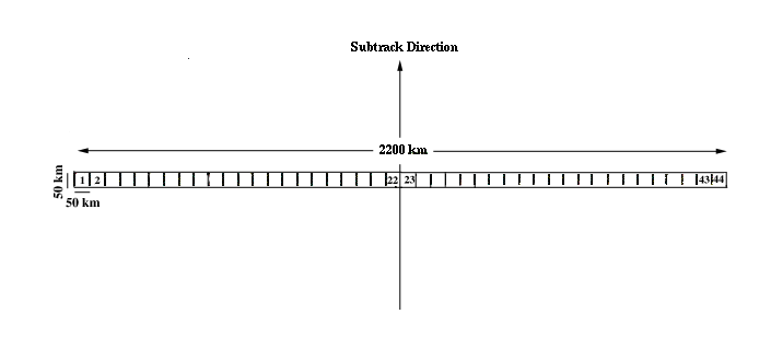
The first step in the reprocessing was to bin the sigma-0 values from the SASS Sensor Data Tapes into 50-km resolution cells so that both the forward and aft radar cross section measurements would be collocated. The 50-km resolution cells were organized into strips which were 2200 km long in the crosstrack direction and 50-km wide in the subtrack direction. Each strip consisted of fourty four 50-km cells. The strips were perpendicular to the satellite subtrack and were bisected by subtrack. Figure 1 shows the geometry of the strips. One orbit of scatterometer data consisted of 820 such strips if there were no data gaps. Each record corresponded to a single strip of data, and each file corresponded to a single orbit (Wentz, 1982).
Figure 1 Geometry for a Strip of SASS Sensor Data
These data were originally available on 16 sigma-0 tapes covering the entire Seasat mission. Each tape was a 9-track, 6250 bpi, with a RECORDSIZE of 1696 bytes and a BLOCKSIZE of 30528 bytes (where 1 byte is equal to 8 bits). Each tape contained about 6 days of data with a short EBCDIC header file at the beginning, followed by one data file for each rev on the tape, as shown below:
Table 1 Contents of the Original 16 9-Track Seasat Tapes
| Tape | Days | Revs | Number of Files | Number of Dat Rec | Missing Revs |
|---|---|---|---|---|---|
| 1 | 188 - 193 | 142 - 228 | 87 | 63282 | |
| 2 | 194 - 199 | 229 - 314 | 86 | 62356 | |
| 3 | 200 - 205 | 316 - 400 | 84 | 59972 | (315), 320 |
| 4 | 206 - 211 | 401 - 486 | 86 | 66803 | |
| 5 | 212 - 217 | 487 - 572 | 86 | 67039 | |
| 6 | 218 - 223 | 573 - 657 | 84 | 64982 | 629 |
| 7 | 224 - 229 | 658 - 743 | 79 | 61560 | 660,671,702-706 |
| 8 | 230 - 235 | 744 - 829 | 81 | 62837 | 745-748,770 |
| 9 | 236 - 241 | 830 - 915 | 86 | 67416 | |
| 10 | 242 - 247 | 916 - 1001 | 83 | 66882 | 998-1000 |
| 11 | 248 - 253 | 1002 - 1087 | 86 | 69022 | |
| 12 | 254 - 259 | 1088 - 1172 | 85 | 68722 | |
| 13 | 260 - 265 | 1173 - 1258 | 86 | 69266 | |
| 14 | 266 - 271 | 1259 - 1344 | 86 | 68464 | |
| 15 | 272 - 277 | 1345 - 1430 | 86 | 69551 | |
| 16 | 278 - 283 | 1431 - 1501 | 71 | 53791 |
The number of files indicated for each tape did not include the header file. If an entire rev was missing, there was no file on the tape for it.
Changes to Original Data Format
s0revNNNN_50km.dat |
||
|---|---|---|
| where: | ||
| s0 | denotes | sigma-naught |
| NNNN | denotes | the four digit rev number |
| 50km | denotes | 50 km cell |
| dat | denotes | RAW Binary data format |
Please note that although the filenames have changed, the data contained in each file are the same as those originally produced by F.J. Wentz.
Each data record corresponds to one 50-km strip which contains
forty-four 50-km boxes oriented perpendicular to the nadir track, and
has the following format:
Table 2 Format of Each Data Record
| First Byte for Type of Element | Number of Bytes Per Element |
Number of Elements | Description of Quantity | Units and/or Offset | Note |
|---|---|---|---|---|---|
| 1 | 4 | 1 | Time of Nadir Point | seconds since beginning of 1978 | A |
| 5 | 4 | 1 | Time of Last Ascending Node | seconds since beginning of 1978 | |
| 9 | 4 | 1 | Longitude of Last Ascending Node | .01 degrees East | |
| 13 | 4 | 1 | Strip Number | B | |
| 17 | 4 | 1 | Geodetic Latitude of Nadir Point | .01 degrees, offset by 9000 |
A |
| 21 | 4 | 1 | Longitude of Nadir Point | .01 degrees East | A |
| 25 | 4 | 72 | Times of Sigma-0 Measurements | seconds since beginning of 1978 | C |
| 313 | 2 | 44 | Number of Sigma-0's in each 50-km bin in strip | ||
| 401 | 2 | 72 | Geod. Latitude of Sigma-0's | .01 degrees, offset by 9000 |
C |
| 545 | 2 | 72 | Longitudes of Sigma-0's | .01 degrees East | C,F |
| 689 | 2 | 72 | Mode + Antenna Cell + Polar + Antenna Number | C,D | |
| 833 | 2 | 72 | Incidence Angles | .01 degrees | C |
| 977 | 2 | 72 | Azimuth Angle of Reference Antenna | .01 degrees | C,F |
| 1121 | 2 | 72 | Instrument and Atmospheric Corrected Sigma-0 | .01 dB, offset by 30000 |
C,F |
| 1265 | 2 | 72 | Standard Deviation of Sigma-0 | .01 dB, offset by 30000 |
C,F |
| 1409 | 2 | 72 | Attenuation | .01 dB, offset by 10000 |
C |
| 1553 | 2 | 72 | Quality Flags | C,E,F |
Note:
strip number = strip number within rev + (rev - 1) * 820
rev= 1 + (strip number -1)/820
strip number within rev = strip number - (rev - 1) * 820
number = mode*1000 + ant. cell*10 + pol.*4 + ant. number
mode=number/1000
ant. cell = (number - mode*1000)/10
i = number - mode*1000 - ant. cell * 10
polarization = (i -1)/4, where 0 = H and 1 = V
antenna number = i - pol. *4
Table 3 describes the bits in the cell data quality flags. By interogating these bits, one can determine the quality of a given SASS measurement.
To determine if a measurement should be included in subsequent wind vector processing the following bits are checked: B1, B2, B4, B5, B6, B7, B10, B11, B13, B16. If any of these bits are turned on, then the measurement is excluded. Furthermore, if B14 is off (indicating no new gain correction is made) and B9 is on, the cell is also excluded.
In going from the SASS Sensor Data Tapes to this data product, any data frames for which the following engineering data quality flags are turned on are excluded from these data: EDQF1(B8), EDQF2(B2), EDQF2(B6), EDQF3(B1), EDQF3(B4), EDQF3(B6).
Bits B5, B6, B8, and B10 are the same as on the original NOAA/EDIS tapes. If any of bits B4, B11, B12, or B13 are on, then B14 will be off, indicating no gain correction is made. Bit B4 indicates that there are not enough good cell temperature measurements to accurately estimate the mean noise power. Bit B9 indicates that a bad system noise temperature may have been used in the calcualtions on the SASS Sensor Data Tapes. Bit B13 indicates a channel overflow for the system noise temperature occurred in the NOAA/EDIS tapes. When this overflow happens, the original value for the mean noise power cannot be recovered from the data on the SASS Sensor Data tapes, and hence no gain correction can be made. Bit 16 rarely turns on, but when it does the cell is definitely suspect and should be excluded from any further processing.
Table 3 Description of Data Quality Flag
| Bit Number* | When bit is on, it indicates: |
|---|---|
| 1 | Land in cell |
| 2 | Mixed land and water in cell or unknown surface type in cell |
| 3 | Data quality summary flag is on for frame |
| 4 | Less than 5 cells in the frame have a system noise temperature between 1175 K and 1375 K for h-pol (1200 K to 1400 K for v-pol) and a signal to noise ratio PR/NP (calculated before the new gain correction) less than or equal to 10. |
| 5 | Voltage VSPN for cell is less than or equal to 0.1 volts |
| 6 | Voltage VSPN for cell is greater than or equal to 7.0 volts |
| 7 | Received power and NRCS for cell are less than zero |
| 8 | Summary latest available data (LAD) from previous calibration sequence is used. |
| 9 | At least one cell in the frame has a system noise temperature (using old tg) outside the 900 K to 1600 K range |
| 10 | Antenna angle PHIONEk for cell is out of range |
| 11 | System noise temperature for cell is outside 1000 K to 1500 K range |
| 12 | Signal to noise ratio PR/NP (calculated before the new gain correction) for the cell is greater than 10 |
| 13 | At least one off-nadir cell (cell 1 through 12) has a system noise temperature (using old tg) greater than 6500 K |
| 14 | New gain correction is made for cell |
| 15 | The equivalent temperature of PSN for cell is four standard deviations below the mean system noise temperature for frame |
| 16 | SIGZDB for cell equals flag value of -199.9 dB, or incidence angles for frame do not increase monotonically |
*Bits are numbered from right to left, with bit 1 being the least
significant bit.
4. Program to Read the Data
A Fortran program entitled read_seasat_031.f is provided to read the Seasat scatterometer global 50-km sigma-0 data on a UNIX system. Unlike other Seasat products, these data were not produced on a DEC/VAX platform. Therefore it is not necessary to swap bytes to read this data on a UNIX system.
PO.DAAC Documentation, "Description for Wentz Seasat Scatterometer forward & aft sigma-naught binned 50km x 50km", pp. 3.
Wentz, F.J., "Documentation for Program Order: Collocating SASS Sensor Data in 50 KM Bins", RSS Technical Report 113082, 1982, pp. 23.
While the filenames, read software and the manner in which the data is provided has changed, the data are the same as those originally produced by F.J. Wentz and described in the Description for Wentz Seasat Scatterometer forward & aft sigma-naught binned 50km x 50km.
For further information about this data set or to place another data order, please contact: